
PlaceMaker for SketchUp is a geospatial data and site-context extension that can import terrain, roads, pathways, buildings, water, railways, trees, aerial imagery, and several types of 3D city data directly into a project. It is designed to reduce the time required to construct surrounding context for architecture, urban design, landscape, visualization, and master-planning work.
Building a convincing site model manually can require tracing roads, approximating surrounding structures, creating terrain, locating vegetation, and aligning imagery from several unrelated sources. PlaceMaker combines many of these operations in one geolocated workflow.
This guide explains the current PlaceMaker workflow, its principal data sources, licensing and credit system, SketchUp requirements, practical use cases, limitations, and the factors to consider before using it on a professional project.
PlaceMaker at a Glance
What Is PlaceMaker for SketchUp?
PlaceMaker is a location-based data platform that allows users to select a geographic area, preview available datasets, and import selected information into SketchUp. Depending on the location and chosen data, this can include topography, aerial imagery, building massing, roads, sidewalks, pathways, railway lines, water features, trees, textured city meshes, and other geospatial assets.
Unlike a conventional asset library, PlaceMaker does not simply place generic buildings or roads around a project. Its primary purpose is to deliver geolocated context based on available mapping, imagery, terrain, and third-party data sources.
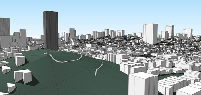
Imported elements can be combined to create a larger site model. For example, users can import terrain first, add an aerial image, and then place or drape buildings, roads, paths, and water directly onto that terrain.
8 Powerful PlaceMaker for SketchUp Features
1. 3D Building Context
Import building footprints and massing data to create surrounding urban or neighborhood context without modeling every structure manually.
2. Roads and Pathways
Generate roads, intersections, sidewalks, paths, and related infrastructure from available mapping data.
3. Detailed Terrain
Import terrain from available global elevation sources and control the grid resolution before adding it to the project.
4. High-Resolution Aerials
Access imagery from providers such as Mapbox, Nearmap, and Hexagon, depending on coverage, location, license, and available data.
5. Google Earth 3D Data
Import textured Google Earth 3D data at selectable levels of detail where the service and regional licensing conditions permit.
6. Trees, Water, and Railways
Add mapped trees, forests, rivers, lakes, pools, coastlines, railways, and other contextual site elements where data is available.
7. Model on Terrain
Drape or place roads, paths, buildings, imagery, and water features directly onto imported terrain.
8. Web and Point Cloud Workflows
Version 4 expands PlaceMaker beyond the SketchUp extension with PlaceMaker Web, shared credits, and additional point-cloud data options.
PlaceMaker City and Terrain Overview
The following preview demonstrates the type of large-scale urban context that can be assembled using terrain, buildings, roads, imagery, and city data.
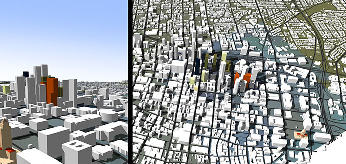
Large context models can combine terrain, mapped infrastructure, buildings, imagery, water, and other datasets.
What Data Can PlaceMaker Import?
Buildings and City Massing
PlaceMaker can use OpenStreetMap and other available building-footprint sources to create surrounding massing. Building detail and height information depend on the source data available for the selected location.
Roads, Walkways, Rails, and Water
Roads, intersections, sidewalks, paths, railway lines, rivers, streams, lakes, coastlines, canals, pools, and similar features can be generated from supported mapped information.
Terrain
Terrain can be imported from supported elevation providers. The level of detail is influenced by the original source resolution and the grid size selected before import.
Aerial Imagery
Satellite and aerial imagery can be imported from global or regional providers. Resolution, capture date, cloud conditions, coverage, and licensing vary according to the selected source.
Textured 3D Cities and Point Clouds
Depending on location and availability, users may access textured photogrammetry-style city meshes, Google Earth 3D data, Nearmap datasets, surveys, and point-cloud information.
AI Land-Cover Data
Optional AI-derived datasets may identify and classify features such as buildings, roads, grass, pavement, open space, sports fields, bridges, and water bodies in supported regions.
Common PlaceMaker Data Providers
- OpenStreetMap
- Microsoft
- Mapbox
- Nearmap
- Hexagon
- Cesium ION
- Ecopia
PlaceMaker Models on Terrain
Combining buildings and infrastructure with topography is one of the most useful parts of the PlaceMaker workflow. Roads, paths, water, buildings, and imagery can be placed or draped onto an imported terrain surface.
Creating Large Urban Context Models
PlaceMaker can be used to create anything from a small immediate-site context to a much larger neighborhood or city model. The appropriate import area depends on the intended presentation, required accuracy, data costs, and available computer resources.
Pay-As-You-Go and Subscription Options
PlaceMaker currently uses a credit-based data system. Users can begin with a free Pay-As-You-Go account, preview the available data for a location, and purchase credits when they are ready to import.
Subscription accounts provide different data costs and benefits. OpenStreetMap 3D imports are currently included for subscribers, while terrain, imagery, textured meshes, point clouds, and selected premium datasets may require discounted credits.
| Access model | Pay-As-You-Go | Subscription |
|---|---|---|
| Initial access | Free account with free data preview. | Annual paid subscription. |
| Import costs | Credits are required for available data imports. | OpenStreetMap imports may be included and other datasets generally receive credit discounts. |
| Credits | Purchased when required and currently do not expire. | Existing credits transfer and may be shared across team seats. |
| Best suited for | Testing, occasional imports, students, and smaller projects. | Frequent users, larger projects, firms, and production teams. |
| Platforms | SketchUp, Revit, or PlaceMaker Web. | SketchUp, Revit, or PlaceMaker Web. |
Preview the Data Before Spending Credits
Data quality, density, age, and availability differ by location. Before completing an import, inspect the preview, confirm the covered area, compare available providers, and check the estimated credit cost.
A Practical PlaceMaker Workflow
- Confirm software compatibility. Verify that the installed SketchUp version supports the current PlaceMaker extension and the selected data type.
- Search for the project location. Navigate to the address, coordinates, or geographic area required for the project.
- Define a reasonable import boundary. Avoid importing an entire city when only the immediate context will be visible in the final presentation.
- Preview available datasets. Check buildings, terrain, imagery, roads, water, trees, and premium data before committing credits.
- Import terrain first when elevation matters. Establishing the site surface first makes it easier to place other contextual objects at the correct relative elevation.
- Add imagery and mapped infrastructure. Import aerials, roads, paths, buildings, water, railways, and trees as required by the project.
- Inspect imported geometry. Check building heights, roads, terrain transitions, reversed faces, overlapping geometry, materials, and tags.
- Optimize the context model. Hide or remove unnecessary areas, reduce excessive texture resolution, and use components or proxy geometry where appropriate.
- Separate design geometry from context. Organize the proposed building and imported site data using clear groups, components, tags, and scenes.
Best Uses for PlaceMaker
Architectural Site Context
Surround a proposed building with terrain, streets, neighboring massing, water, vegetation, and aerial imagery for more informative presentations.
Urban Design and Master Planning
Build a rapid base model for evaluating street networks, blocks, building density, public spaces, massing proposals, and urban-scale views.
Landscape and Terrain Studies
Import terrain and mapped site features to study slopes, drainage context, paths, vegetation, water bodies, and relationships between the project and surrounding landform.
Rendering and Animation
Generate broader background context for aerial views, approach animations, site flyovers, real-time rendering, and large exterior visualization scenes.
Early Feasibility Studies
Quickly assemble a preliminary context model before detailed survey, consultant, BIM, or civil-engineering files become available.
PlaceMaker Compared with Native SketchUp Add Location
| Workflow | Native SketchUp Tools | PlaceMaker |
|---|---|---|
| Terrain and imagery | Provides a basic geolocation workflow with available imagery and terrain capabilities depending on the SketchUp version. | Offers multiple terrain and imagery providers with selectable coverage and quality. |
| Building context | Surrounding building geometry normally requires manual modeling or external files. | Can import available building footprints and massing data. |
| Roads and paths | Usually traced or modeled manually. | Can generate roads, intersections, sidewalks, and pathways from mapped data. |
| Water, rails, and trees | Usually created manually or imported from separate sources. | Can import supported contextual data within the same workflow. |
| Textured 3D city data | Not a standard native city-import workflow. | Supports selected Google Earth and Nearmap-style 3D datasets. |
| Pricing | Included with the relevant SketchUp features. | Uses Pay-As-You-Go credits or an annual subscription. |
Performance Tips for Large Context Models
- Import only the geographic area that will be visible or required.
- Use lower-detail terrain or 3D data for distant background context.
- Keep terrain, buildings, roads, water, trees, and imagery on separate tags.
- Turn off large context tags while editing the proposed design.
- Reduce oversized aerial textures when full resolution is unnecessary.
- Avoid importing multiple overlapping datasets for the same area.
- Save incremental copies before performing large or expensive imports.
- Purge unused materials, components, tags, and styles after testing.
- Use a polygon-reduction tool when imported mesh data is too dense.
PlaceMaker Data Is Not a Replacement for a Professional Survey
Geospatial, mapping, aerial, terrain, building, and AI-derived datasets can be extremely useful for context, visualization, planning, and early studies. However, their accuracy, age, resolution, completeness, and permitted use vary by provider and location. Do not rely on imported data for legal boundaries, construction setting-out, structural decisions, property disputes, or other survey-critical work without verification by qualified professionals.
Possible Limitations
PlaceMaker cannot guarantee that every dataset is available in every city. Building height, tree, road, terrain, imagery, mesh, and point-cloud coverage varies according to the original provider and geographic location.
Imported data may also differ in capture date. Aerial imagery, roads, building footprints, and textured city models may not reflect very recent construction, demolition, landscape work, or infrastructure changes.
Large imports can create substantial SketchUp files. Detailed terrain, textured meshes, aerial imagery, trees, roads, and thousands of buildings may affect orbiting, saving, synchronization, rendering, and memory usage.
Costs can vary depending on the selected data type, location, import area, resolution, account type, and number of credits required. Always review the preview and estimated cost before finalizing an import.
Data-provider attribution, licensing, API restrictions, and permitted uses must also be respected. Requirements may differ between OpenStreetMap, Mapbox, Nearmap, Hexagon, Cesium, Google, Microsoft, and AI-derived datasets.
Is PlaceMaker Worth Using?
Our Assessment
PlaceMaker can provide substantial value when a project requires more than a simple flat background or generic city model. Its principal advantage is the ability to access several types of geolocated context through one coordinated workflow.
Architects, urban designers, landscape designers, visualization studios, developers, and master-planning teams can save considerable preparation time when roads, terrain, neighboring buildings, imagery, water, and vegetation would otherwise need to be collected and aligned manually.
The Pay-As-You-Go option is useful for occasional users and testing, while a subscription may offer better value for users who import OpenStreetMap and premium datasets regularly.
Before committing to a large import, test the actual project location, inspect the available data, compare credit costs, confirm software compatibility, and determine whether the resulting detail is appropriate for the final camera distance and project purpose.
Related SketchUp Resources
- Explore SketchUp Plugins
- Best Free SketchUp Plugins
- Premium SketchUp Plugins
- How to Install SketchUp Plugins
- Skimp for SketchUp Guide
- SketchPlus for SketchUp Guide
- Artisan 2 for SketchUp Guide
- Online SketchUp Courses
- Premium SketchUp 3D Models
- Official PlaceMaker Website
- PlaceMaker Data Attribution and Terms
Frequently Asked Questions
What does PlaceMaker do in SketchUp?
PlaceMaker imports available terrain, aerial imagery, buildings, roads, pathways, railways, water, trees, textured city data, and other geospatial information into a SketchUp project.
Which SketchUp versions support PlaceMaker?
At the time of review, the current PlaceMaker extension required SketchUp 2021.1 or newer. The latest requirements should be verified before installation.
Can PlaceMaker import Google Earth 3D data?
Yes. PlaceMaker currently provides Google Earth 3D data options. SketchUp Pro 2022 or newer is required for Google 3D imports, and availability or API requirements may vary by region and account type.
Is PlaceMaker free?
Users can currently create a free Pay-As-You-Go account and preview available data. Credits are generally required to complete imports. An annual subscription is also available.
Do PlaceMaker credits expire?
The official credit information currently states that purchased credits do not expire. Terms may change, so verify the current policy before purchasing a large credit balance.
Can PlaceMaker generate terrain?
Yes. PlaceMaker can import terrain from supported elevation sources and allows users to control the grid detail before import.
Can roads and buildings be placed on terrain?
Yes. PlaceMaker can model or drape supported roads, paths, buildings, water, and imagery onto an imported terrain surface.
Is PlaceMaker data survey accurate?
PlaceMaker data can be useful for context, visualization, planning, and preliminary studies, but it should not be treated as a replacement for a verified professional survey.
Can PlaceMaker create very large city models?
It can import large context areas, but file size, processing time, texture memory, data cost, and SketchUp performance should be considered before selecting a large boundary.
Does data quality remain the same everywhere?
No. Coverage, resolution, accuracy, capture date, building detail, terrain quality, imagery, trees, and premium data vary by provider and geographic location.
Is PlaceMaker suitable for beginners?
The basic selection and import workflow is approachable, but users should understand SketchUp groups, tags, geolocation, terrain, textures, and performance optimization before creating large context models.